Study region
The study region of the project is located in the Autonomous Prefecture of Xishuangbanna (19.700 km2) in the southern Yunnan province, Southwest China. This mountainous region borders on Laos and Myanmar and is crossed by the upper Mekong River from north to south. The region has a typical monsoon climate characterized by a distinct rainy season (May-October), followed by a cool dry season (November-January) and a hot dry season (February-April). Average annual temperature is around 21° C and annual precipitation is around 1.200mm. About 95% of the rubber plantations in Xishuangbanna are found below 900m asl. and cover 20% of the total land area.
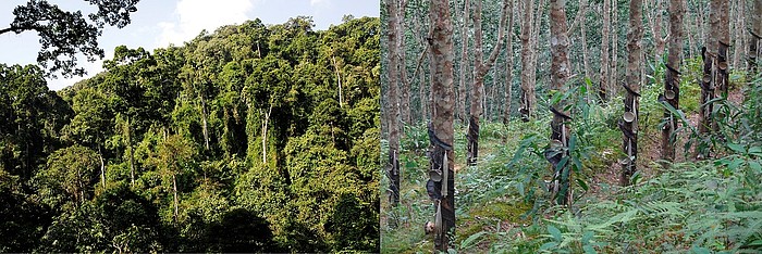
The natural vegetation up to this elevation is tropical rain forest and seasonal monsoon forest, representing the still largest and most important rainforests of China. Xishuangbanna is also known for its cultural diversity, represented by more than ten ethnic groups with different traditions and land use types.
The specific study areas of the project are two catchments (nature reserves) of different land use. One area represents a close-to-nature situation (dominated by natural forest), the other is strongly influenced by rubber plantations.


A great diversity of vegetation can be seen in Xishuangbanna, due to the intersection of both south- and east-Asian Flora, together with tertiary relic genera and montane elements from the Himalaya, making this part of the “Indo-Burma hotspot of biodiversity”. In the NNNR alone, there are 1953 species of vascular plants, from 219 different families, which are used and sometimes sold by the local population. With 384 species of vertebrates, the fauna is also quite diverse. Many of these species are under national protection; the “Nabanhe Nature Reserve”, which had been established since 1991, was promoted to the status of “National Nature Reserve” in 2000. Cultivation of the area is practiced according to the concepts of the “Man and the Biosphere” programme of UNESCO, with various zones having different protection or cultivation status.
In addition to ecological variety, there is also ethnic and cultural diversity to consider. The area’s population of approximately 5500 people in 32 villages can be distinguished into six independent ethnic groups: Han, Dai, Hani, Lahu, Bulang and Yi. Among the larger groups, the Dai and Han live in the valleys, while the Lahu live in the hills. The most important source of income is agriculture; aside from rice, corn and potatoes, they also cultivate peanuts, sunflowers, tobacco, vegetables, tea, Sharen (Amomum villosum) and various species of fruit trees, in addition to an increasing proportion of rubber cultivation. The different cultures belonging to the different ethnic groups are also reflected in the different forms of land use. The Lahu are hunters and gatherers that depend on the forests, the Dai are rice farmers, and the Han are active in rubber cultivation.